
The why's and how's of learning geospatial
Introduction
Section titled “Introduction”This module provides a short introduction to why learning geospatial is important and how you can start learning GIS.
What you should already know
Section titled “What you should already know”Since this is a beginner module, no previous knowledge of GIS or QGIS is required.
Why learn geospatial in general and QGIS in particular?
Section titled “Why learn geospatial in general and QGIS in particular?”Imagine you had population data and flood hazard data and you wanted to know how many people are at risk or flooding. Or maybe you are working for a development organization and you want to know how many people are possible beneficiaries of your projects and where underserved areas are by using the location of households, road network data, and the location of your projects and interventions. Or you could be a company trying to identify which stores can best handle specific deliveries or customer demands using data about your customer locations, store locations, and store inventories.
Everything is a layer
Section titled “Everything is a layer”If you’ve worked with geospatial data before, you’ve probably heard at least one of the following sayings:
- “Everything happens somewhere.”,
- “80% of data has a geographic component.”, or
- “Everything is related to everything else. But near things are more related than distant things.”
The last one is also known by its more popular name as Tobler’s First Law of Geography.
At its core, Geographic Information Systems (GIS) and geospatial analysis are simply tools used to answer questions and solve real-world problems. They achieve this by modeling the real world through the use of geospatial data models, which represent objects such as land use, elevation, lot parcels, etc. (Figure 1).
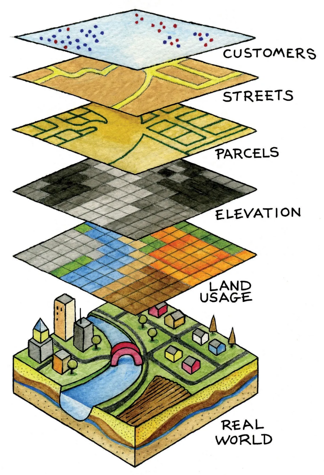
In later chapters of this workbook, we will discuss these models in more detail. For now, think of them as variables that you can use to solve a problem.
A GIS can read these models as layers which can be combined, manipulated, processed, analyzed, and visualized to study their relationships, find patterns, gain insights, and, ultimately, make informed decisions.
With a strong foundation in GIS concepts and techniques, you can harness the power of geospatial across a variety of areas and industries. The ability to interpret, analyze, and visualize data in a geospatial context is particularly valuable in fields such as environmental science, urban planning, public health, transportation, climate change, and disaster risk management among others.
By applying GIS techniques to real-world problems, you can uncover hidden patterns, trends, and relationships that may not be visible through traditional analysis methods. This enables you to make informed decisions and develop effective strategies that are tailored to your specific needs. Whether you are working in academia, government, or the private sector, the knowledge and skills gained from this workbook will help you to apply GIS to a wide range of applications and domains.
Sample applications of QGIS
Section titled “Sample applications of QGIS”QGIS for field data collection
Section titled “QGIS for field data collection”QGIS can be a valuable tool for field data collection, enabling you to collect and manage geospatial data from field.
One common application is in environmental research, where field biologists can use QGIS to record the locations of species sightings, vegetation types, and other environmental features. This data can be used to create maps and analyze patterns of species distribution, helping to inform conservation efforts and land management strategies. Mapping Invasive Weeds in Swan Bay, Australia: Mergin Maps case study and Improving Efficiencies in Ecological Surveying using QField are some examples.
Another common application is in asset management, where field technicians can use QGIS to collect data on infrastructure such as pipelines, power lines, and water treatment facilities. By capturing location data and asset information in the field, organizations can better track their assets, monitor maintenance needs, and plan for future upgrades. This can be seen in the Data collection by QGIS/QField for O&M work of rural water supply systems in Rwanda.
In agriculture, QGIS can be used for precision agriculture, where farmers use geospatial data to optimize crop yields and reduce waste. By collecting data on soil type, crop health, and weather patterns, farmers can create maps that show variations in crop growth and tailor their management practices accordingly. You can read Pecan Precision Farming with Input App: Mergin Maps case study for an example.
In terms of tools for field data collection, QGIS can utilize QGIS-specific and general purpose applications.
QGIS-specific field data collection applications include: QField and Mergin Maps. These tools integrate directly with QGIS and allows you to bring your QGIS project to the field. Both are open source, mobile-friendly, and allow for field data collection projects to be set up in QGIS, field data collection to be done via a dedicated mobile application, and the data to be synced to QGIS when done. This direct integration with QGIS allows you to streamline your field data collection processes, improve data accuracy, and enhance collaboration between team members.
General-purpose field data collection tools with geotagging support can also be used with QGIS. This includes applications such as ODK, ODK-X, and Kobo Toolbox.
QGIS as a site-suitability or decision-support tool
Section titled “QGIS as a site-suitability or decision-support tool”QGIS can also be used as a powerful site-suitability or decision support tool. Site-suitability analysis is the process of evaluating different locations for their suitability for a particular use or activity. For example, a real estate developer may use QGIS to identify suitable locations for a new housing development, taking into account factors such as zoning restrictions, environmental factors, and accessibility.
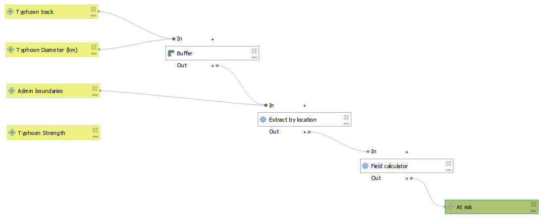
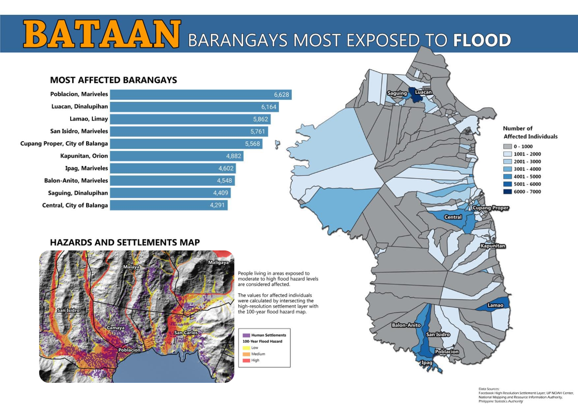
Similarly, QGIS can be used as a decision support tool for a range of applications. Decision support systems are used to help people make informed decisions by analyzing data and presenting it in a way that is easy to understand. In the context of GIS, decision support systems can help users to evaluate different scenarios and visualize the impacts of their decisions on the environment, infrastructure, and other factors. One example is a mapping barangays most exposed to floods to identify the proper mitigation and response prioritization in case of disasters.
QGIS allows you to gain valuable insights into the relationships between different variables and make informed decisions based on the best available data.
Examples from past training (SSA)
Section titled “Examples from past training (SSA)”Tropical Cyclone Risk Assessment Model by PDRF (Philippines) during the Open Geodata Training Programme by OKFN and Data4Good at Meta
Mapping areas most exposed to flood by UPRI (Philippines) during the Open Geodata Training Programme by OKFN and Data4Good at Meta
Network analysis with QGIS
Section titled “Network analysis with QGIS”QGIS is also a powerful tool for network analysis—the process of analyzing and optimizing transportation and communication networks. QGIS includes a range of network analysis tools, such as network analysis algorithms and plugins, that enable you to analyze and perform complex network analysis tasks, such as route optimization and vehicle routing, with relative ease. For example, Shortest path algorithm find the shortest path between two points on a road network, taking into account factors such as traffic flow and speed limits.
Network analysis can be used to solve a wide range of problems. Examples of network analysis that you can do in QGIS include:
- Finding the fastest/shortest paths
- Finding the nearest hospital
- Isochrone and service area analysis
- Finding underserved communities
- Accessibility analysis
- Optimal allocation analysis
- Service capacity analysis
- Walkability or PWD accessibility score
- Finding routes with green spaces
- Finding pleasant routes
Examples from past training (Network analysis)
Section titled “Examples from past training (Network analysis)”Case study - Designing a 15-minute city with high resolution population data
And many more…
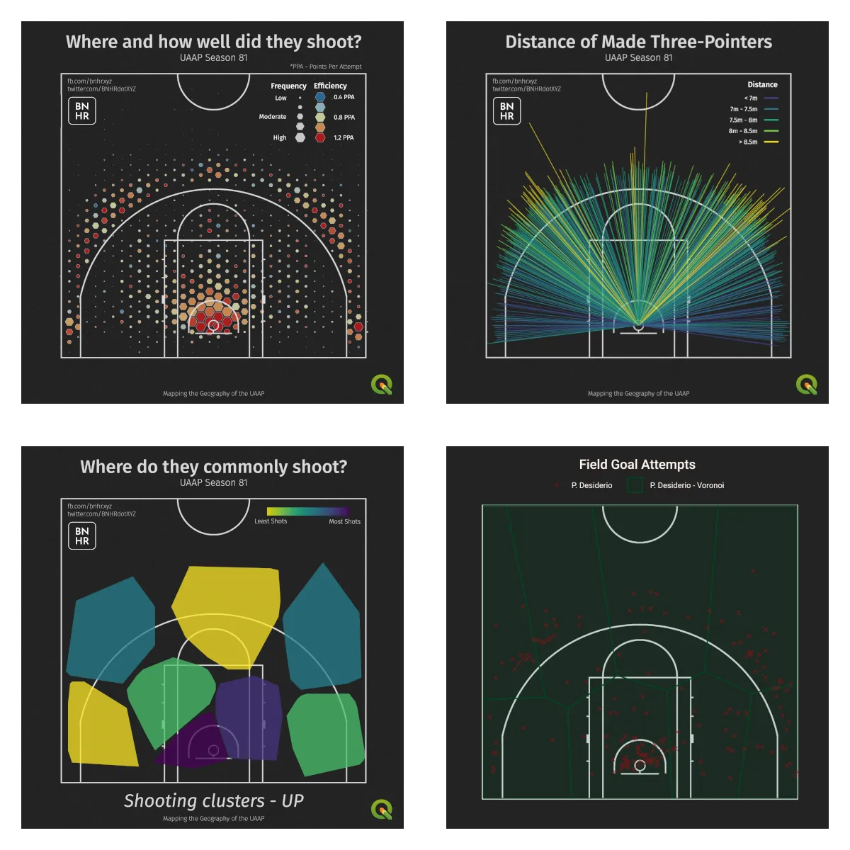
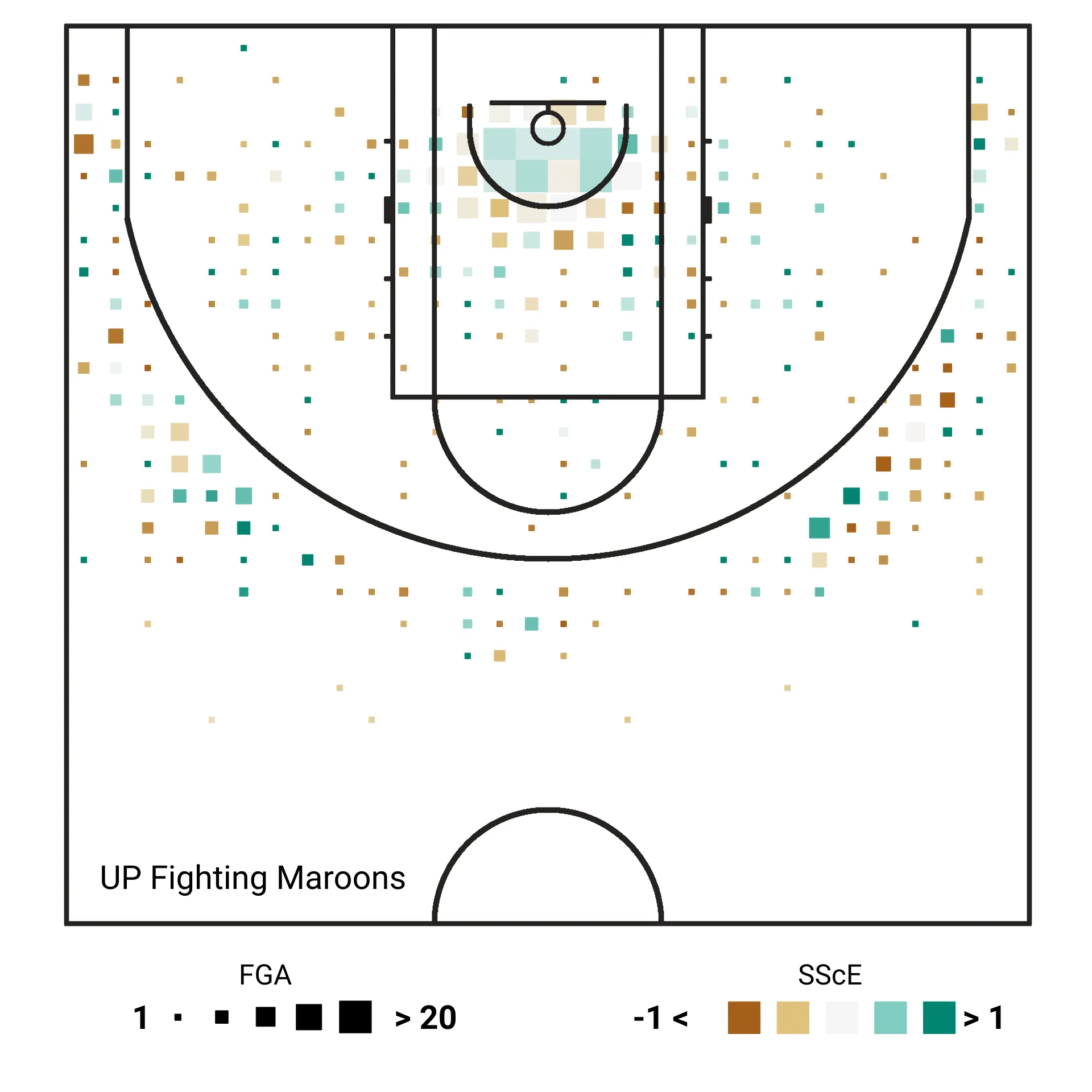
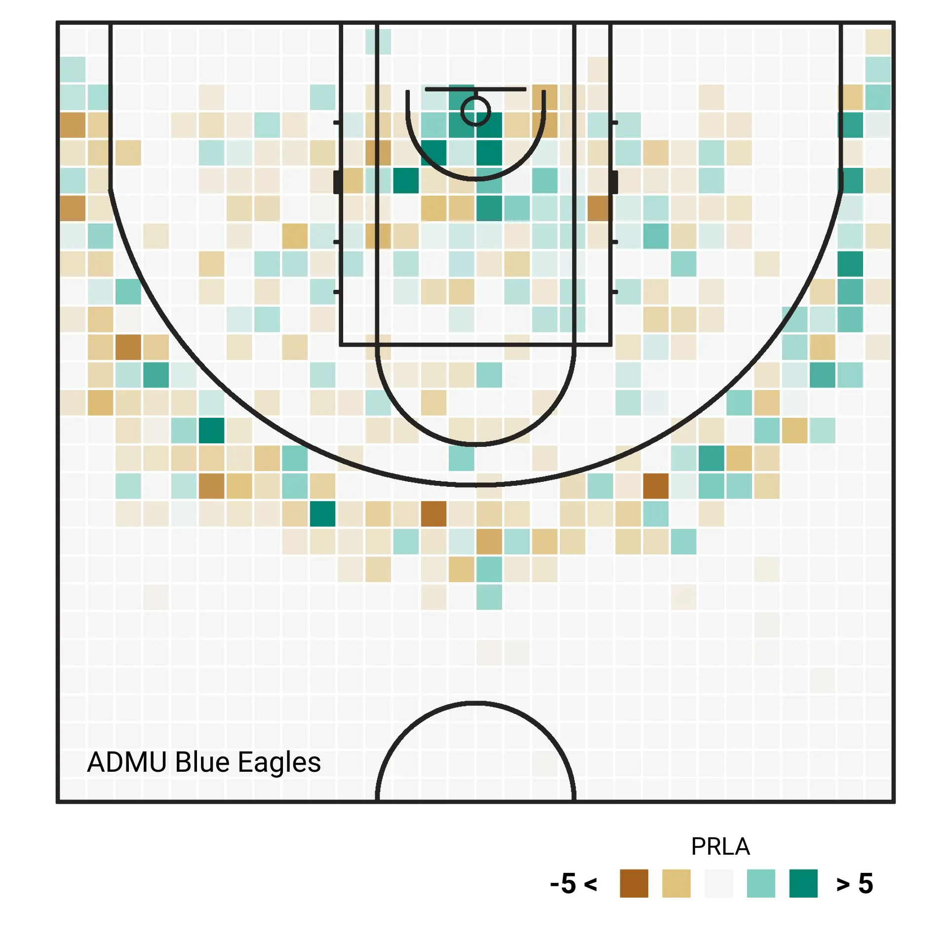
Section titled “And many more…”You are only limited by your imagination on where and how you can use QGIS. Personally, I’ve used QGIS to spatially analyze and visualize Philippine basketball—the UAAP Season 81 Men’s Basketball Tournament in particular—for my Master’s Thesis. Example maps/visualizations I created for that are shown below:
How can I start learning about GIS or geospatial?
Section titled “How can I start learning about GIS or geospatial?”Are GIS, geospatial, and mapping all the same?
Section titled “Are GIS, geospatial, and mapping all the same?”GIS, geospatial, and mapping are terms that are typically used interchangeably but it is important to understand the nuances of these terms because while they are related, there are distinctions that set them apart from one another.
GIS or Geographic Information System - system that allows for spatial information to be created, stored, manipulated, analyzed, and presented.
Geospatial - refers to the field that includes the collective data, techniques, and technologies that incorporate a geographic or locational component. This includes the tools and methods used to gather, store, analyze, and interpret geospatial data.
Mapping - the act or process of creating a map, visualizing geodata, or representing a part of the world through a map. Mapping is one—and probably the most well-known—function or products of a GIS, but it is not the same as GIS or geospatial.
You can think of it this way: GIS is part of the geospatial field and mapping is one of the functions/products of a GIS.
Open geospatial and FOSS4G applications
Section titled “Open geospatial and FOSS4G applications”GIS is free and open.
- Learning and using GIS and other geospatial software need not be expensive.
- There exists powerful free (as in freedom) and open source software for working with geospatial data.
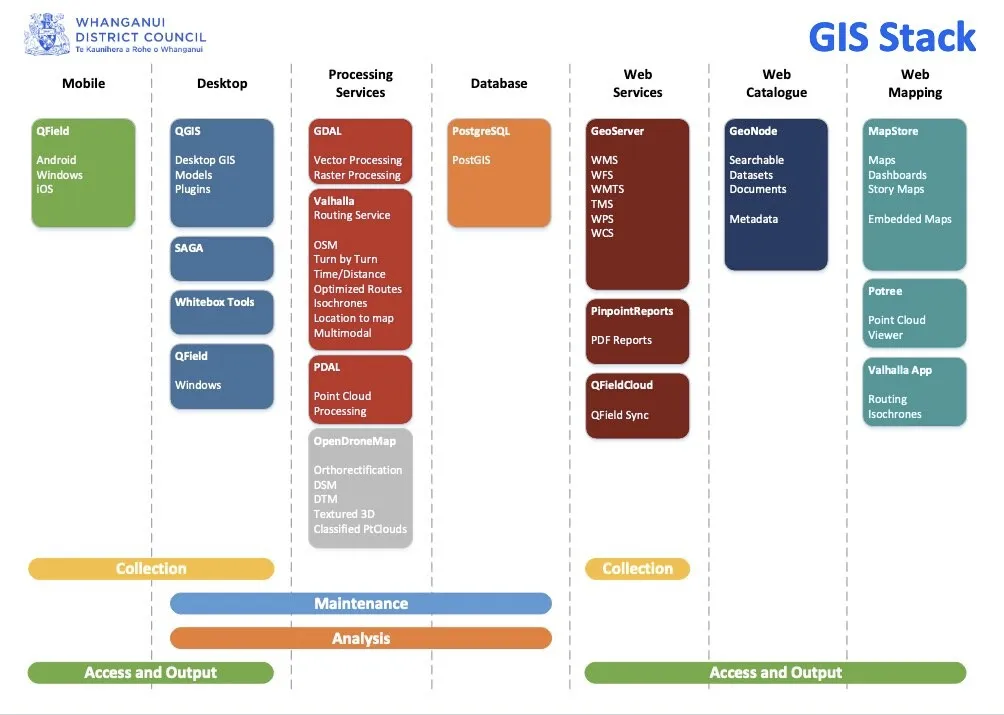
QGIS is part of a larger category of software known as Free and Open Source Software for Geospatial (FOSS4G) applications. These include other tools such as GRASS, PostGIS, GeoServer, and GeoNode. FOSS4G applications are powerful tools for working with geospatial data, not only because they are reliable, but also because they are free and open source. This lower barrier of entry means that these tools are accessible to a wider range of users and can be customized to meet specific needs. In fact, there are many different FOSS4G applications available for every stage of the geospatial workflow, making it possible to find a free and open source solution for nearly any need.
Free software
Section titled “Free software”Free as in freedom not just free food.
Free software are software that adhere to the Four Essential Freedoms of Free Software, which are:
- The freedom to run the program as you wish, for any purpose (freedom 0).
- The freedom to study how the program works, and change it so it does your computing as you wish (freedom 1). Access to the source code is a precondition for this.
- The freedom to redistribute copies so you can help others (freedom 2).
- The freedom to distribute copies of your modified versions to others (freedom 3). By doing this you can give the whole community a chance to benefit from your changes. Access to the source code is a precondition for this.
Open source
Section titled “Open source”Open source software are those that have licenses which provide royalty-free use and reuse of the software together with open access to the source code. By convention, these open source licenses are those that comply with the Open Source Definition as provided for by the Open Source Initiative. Open source not only guarantees free access to the software and source code but also the ability to redistribute the software with no additional costs.
Because of the open nature of open source software, it is also a great software development model where everyone is free to update, upgrade, modify, and share their modifications to the community.
There are a lot of open source geospatial applications out there and sometimes the most difficult part is knowing where and how to start working with these applications. This is where the Open Source Geospatial Foundation (OSGeo) (https://www.osgeo.org/) comes in. OSGeo is a global not-for-profit organization that helps foster global adoption of open geospatial technology and supports the development of these technologies. I am a Charter Member of OSGeo—one of only four from the Philippines.
Certification and Support
Section titled “Certification and Support”Contact us or sign-up to our courses if you are interested in having this as an instructor-led or self-paced course.